Fig 1
Older’s farm or Charity Land as in 1839
Enclosure 538 having been exchanged in 1812 so as to move it from Roundstone.
(Part 4, Chapter 1, Section 3, Sub-Section 6) ( BK. Index )
The William Older Charity School is well known, albeit now as the village library. What is less well known is the history of Older’s farm and cottage in Station Road, the land that provided the considerable income for financing the school. This is the history of the farm rather than the charity.
1. Oulder Family and Lands
A distinguishing feature of East Angmering, south of the village, is that it was the focus of open field farming in Angmering until the 19th century. Yet, as early as the 1679 survey, the western side against Station Road – by its modern name – was largely occupied by groups of inclosures comprising substantial parts of small farms. The Palmer family group of fields to the north, Gratwicke to the south and Older’s Cottage farm between. Perhaps the only common factor, was in each of these families having been owners of part at least of the manor of Ham or, in the case of Palmer, of Angmering. Their manor farms were separate from the commons, and they were able to use their influence to take these other lands out as well. As a complication to the picture, part of the Gratwicke land was not considered to be in East Angmering manor but Ham. Ham manor also had outliers in East Preston.
The Older [Oulder or Owlder] family were most notable in the 16th century, as extensive owners and occupiers of land in Ham, and as part owners of the manor itself. Thomas Older acquiring title from the Lewknor family, with this passed on to three daughters and by their marriage out of the Older family. How this older generation was related to William of East Angmering is as yet entirely obscure.
William Older, in not uncommon fashion, may have mourned a wife or two previous to the one that survived his decease in 1680. Sarah continuing to enjoy the profits of their farm until her death in 1690. Although William died at Angmering in March 1679 by the old calendar – 1680 by the modern – he also seems to have lived at Kingston where he had extensive property. But it is not possible to trace his farm and cottage in Angmering prior to 1679, and so it is quite fortuitous that the survey of that year was made just before William died.
In his will he left useful sums of money to close relatives, and to many others who may have been related in some way. Most of his properties were either freehold, or copyhold of inheritance, which means they descended according to the occupiers will. Therefore, to find that he acquired a large Kingston copyhold from William Kempe – so it can be deduced – and in 1680 left good sums of money to relatives, including £10 to the daughter of Thomas Kent, is at least suggestive. It is also of relevance that John Kent of Heene [Kempe?] was married into the Olliver family, for reasons which will be made clear in the next paragraphs. If it had not been for William’s misfortune in losing all his children, these farms would have descended through his family, and Angmering would have had no reason to celebrate the Older name.
Definite kinsmen in 1680 were Henry Older of Coldwaltham, and William Older of Watersfield. Other beneficiaries included numerous members of the Brinsbury family, Studman who was given the residue of a lease in a farm at Ham, Mary Knight of Dorking, John Farncome of Tarring, and Thomas Adams of Angmering, besides godsons.
It is also suggestive that in 1657, Elizabeth, a daughter of a William Older of Kingston was buried at Angmering. The chapel at Kingston had been abandoned to the sea in 1626, and the residents there would normally have used Ferring church. Then again, in 1670 the hearth tax for Kingston included a substantial farmstead in the Street, with three hearths, owned by a William Older. And finally, it was only shortly prior to William of Angmering making his will that he relinquished his properties in Kingston. It has to be assumed, all of these individuals were one and the same, and he had been residing at Kingston for much of his life, only coming back to Angmering towards the end in 1680.
“And whereas at a Court holden fo the Mannor of Kingston the Fourteenth day of Aprill now last past [1679] I have surrendered into the hands of the Lord of the said Mannor diverse Coppyhold lands & Tenements held by Coppy of Court Roll of the said Mannor to the use of my last will & Testament.” [HC524]
Which brings us to the whole focus of his will. That he entrusted the Angmering farm to Thomas Olliver of Kingston and Angmering for the purpose of founding a school charity. And even more central to the matter, that he bequeathed the whole of his copyhold and freehold estate in Kingston to William Olliver, the son of Thomas.
Although they were not described as relatives, it seems they were. The father of Thomas Olliver, another William, had married Margaret Godman. She was the heir of Thomas Godman of Angmering, and he had reputedly married one of the daughters of Thomas Older of Ham, and owner of part of that manor. This part of the manor, comprising houses and well over a hundred acres of land, being sold by William Olliver and wife Margaret Godman to Humphrey Gratwicke in 1647, according to a deed now seemingly lost and another that still exists. [Add Mss 13272 and HC 1023] As a word of caution though, the descent of Ham in the 16th and early 17th century was a very involved business, and it may be doubted that any history has the entire picture.
The question arises whether Older’s Cottage and its farm were residues of the Ham estate, kept by the family, and descending to William Older the school founder.
However, something more substantial is known of the Kingston estate, and its relevance to Angmering.
William Older was a tenant in Kingston by 1653, at which time he took over a 32 acre copyhold – in fact four copyholds combined – from Kempe, or Kent, who had held them from 1635 or earlier for a rent of 39s 4d. The only two freeholds that existed in Kingston amounted to a mere eight acres, and these also belonged to William Older, at 2s 4d rent. Much of the acreage of these lands lay in the extensive open fields of the village, an amazing fifty separate plots ranging from five acres down to a mere quarter acre. It is therefore virtually impossible to map his farm in any useful fashion.
A set of copyholds amounting to twenty acres, were the next acquisition in 1656, but converted to leasehold for 21 years at £10 rent. This farm however was not mentioned in Older’s will, with it by then being let out by the lord of the manor to others.
His will makes quite unmistakable reference to the copyhold and freehold, and for these to be devised to William Olliver the son of Thomas.
And whereas at a Court holden for the Mannor of Kingston the Fourteenth day of Aprill now last past I have surrendered into the hands of the Lord of the said Mannor diverse Coppyhold lands & Tenements held by Coppy of Court Roll of the said Mannor to the use of my last will & Testament
Now I doe hereby give & devise All & Singuler the said Coppyhold Lands &c Tenements with the appurtenances unto the said William Oliver To have & to hold the same unto the said William Olliver his heyres & assignes for ever according to the Customs of the said Mannor
Also my will & intent is that the said William Olliver his heyres & assignes shall from time to time pay out of these Freehold Lands lying in Kingston & Goring the summ of Twenty shillings per Annum to the poore of the parrish of Angmering aforesaid to bee distributed according to the discretion of the churchwardens & overseers
And Ten shillings every yeare to a Minister to preach a sermon yearly for ever uppon the same day I am buryed.
William Olliver did take these land and it can only be supposed that, to begin with, the twenty shillings dole to the poor was paid, and the ten shillings for a sermon. This last may be seen as the Protestant equivalent of the Catholic trental of masses said for the dead. Thomas Olliver died in 1687 and William in 1736, and the lands continued in their family until they took over Kingston manor in its entirety
2. Older’s Charity Land
The lands William owned in East Angmering were mentioned in the 1679 Survey of Angmering, conveniently made one year before his decease, otherwise their origin would be more speculative.
Allso William Oulder holdeth freely of the Lord of this Mannor as of the said Mannor to him and to his heirs for ever One Tenement being a Messuage and Thirty five acres of Land with the appurtenances lying and being in East Angmering aforesaid bounded as followeth (viz)
One feild inclosed containing by estimation Thirty two acres bounded by the Lands of Joane Penfold widdow called the Earth pitt on the North by the West Common feild the Lands of John Sturt and certain Lands of Humphry Grattwick gent called Irishes on the East by the Lands of Olliver Weeks Esq on the South and by the High way leading from Angmering to West Preston on the West.
Allso three acres inclosed bounded by the lands of Olliver Weeks Esq on the North by the Highway on the South and west and by the lands of Mary Baker on the East
and hee payeth rent by the yeare therefore Eight shillings And holdeth by Rel. Suit of Court and other services
[Margin notes of the early 18th century] Acres xxxv Free School Land Rent viijs
It should be made clear that his 35 acres was by traditional measure, and rather more than its statute acreage.
Earth Pitt to the north is where Dell Nursery and now The Dell housing estate is located.
Rustington bypass cuts through the southern boundary of his farm, so that Weeks land was south of that. The highway is now Station Road.
In other words this is largely the playing fields of the Angmering county comprehensive school, which opened in 1975, being nicely placed there, but not as a new Older’s School. St. Margaret’s in the north of the village bears that mantle.
It is notable that all of his land was inclosed and compact, whereas much of East Angmering remained in common field strips. Even more remarkable that the whole 32 acres was described as ‘one field’, for few inclosures were anything like that size. It could mean that it had only recently been taken in from the open fields. In later years it did become several inclosures, probably to enable them to be leased out piecemeal to suit demand. The cottage also made a separate lot for renting out.
The only detached portion of the farm was the, three acres’, adjoining a highway on the south. This field is positively identified as land next to Roundstone Lane where the public house is situated and south to the caravan site at Roundstone Crossing. It was not until 1812, when the inclosure agreement for Angmering was finalised, that an exchange was made, and this three acres was transferred to adjoin the main block of land on the east.
Rentals for Angmering do not now exist, until a series that begins after 1680, and so nothing is mentioned of this freehold until his wife Sarah, died in 1690. There is then an entry recording the receipt of 6d heriot for a copyhold she had owned in Angmering Street, and a relief of 9s 1d as an entry fee to two freeholds. These would have been paid by Thomas or William Olliver to the steward employed by Bishopp of Parham. The two freeholds could only have been for Older’s Cottage and farm, but whether the land was two old tenancies or the cottage and land separate is entirely unknown. [Acc 9163]
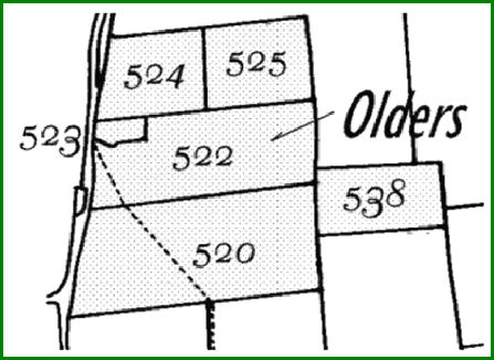
In the Tithe Apportionment of 1839 a fairly accurate survey gives a total of 32 acres 1 rood and 27 perches, which is 32.42 acres, or 13.12 hectares, for the farm. This includes the cottage. The map below outlines the fields, together with Older’s Cottage – although this ancient house no longer exists.
A freehold rent of 8s was paid by William Older to the Lord of the Manor, but this must not be confused with the market value of the farm, if let out by him to a tenant. He might have obtained a rent of that much per acre. Indeed in 1724 the property was said to be worth £25 to the charity, meaning the rent obtained at that time, which could not have altered much since 1680.
There is a note in Older’s will that prohibited ploughing of the grassland by the schoolmaster, other than if he paid a sort of fine, ten shillings per acre to the poor annually. Whether he actually meant that if the schoolmaster used the farm himself he was to pay this as a rent for it, is not clear. There is no obvious reason to protect the land as grazing, but in the Tithe Map it was still all grass. Unfortunately no earlier surveys exist to confirm that it had been so from 1680.
Tithe Apportionment 1839
Older’s Charity - owner
All described as School Land and grass
Tenants
William Amoore
520 11.84375 acres
538 3.75000
Henry Baker
524 3.8125 acres
525 4.09375
John Cortis
522 8.13750 acres
George Green
523 Cottage and garden 0.78 acres
32.42 acres in total
A money charge in lieu of tithes in kind to be paid to the rector, totalled £8 13s 3d, or 5s an acre. This charge did in fact vary according to the price of corn as published. But was an additional charge to add to rent paid into the school charity.
|
Fig 1 Older’s farm or Charity Land as in 1839
|
Charity reports provide notes of income, representing the rent from this land. From £25 in its earliest days, it rose through £40 in the late 18th century to £105 in the inflationary years of the early 19th century. It then reduced slightly, until about the time of the Tithe Apportionment under £3 an acre was being charged.
For the 1860s onwards until at least the 1870s, fuller accounts survive, when three tenants of the land were paying £96 10s and the cottager £6. [Par/25/1]
Oct 11th 1862
Recd of George Green 1 years Rent of School Cottage due Oct 11 £6 0s 0d
Jan 16th 1863
To Half Years rent due at Michaelmas 1862 from
Mr Amoore £23 5s 0d
Mr Cortis £12 0s 0d
Mr Belchamber £13 0s 0d
£48 5s 0d
3. The House
Only one house is relevant to this history, Older’s Cottage itself. Sadly this has entirely gone, and is replaced by a new bungalow. There is at present no adequate recollection or photographs of the house for anything substantial to be said about it. Merely that it was a medium sized building, more than four rooms, and not one of the greater farmsteads of the village.
There is one probate inventory which appears promising, made for John Owldar in 1624. He evidently had a small house and no great farm, with only 26 acres of land mentioned, together with a few cattle and 45 sheep. On finding his will [A Dean 9] it transpires that he lived in West Angmering, and so perhaps at the copyhold owned by Sarah Older prior to her decease in 1690. It was not Older’s Cottage.
Amongst all the inventories and wills that exist , it is likely that one or two do relate to this property, but identifying them may be impossible.
A rent of £6 for the cottage, in the 19th century, compares with 1s 6d rent per week for each of the Longback Cottages, which is £4 a year. Another comparison is its rate valuation of £6 in 1910, which is exactly the same as most of the Longback Cottages, although the vast majority of labourers cottages were rated at £3 and £4. Pigeonhouse farm at this time was considered very dilapidated but still worth £8, whereas two other old farmsteads, Upper Ecclesden and Avenalls were valued at £14 nd £16. [IR4]
At some future date the required keys to the past may be found, and a more substantial history written.
RWS 2/1/09 NRD